RESOLV™ is software as a service for companies that collect and sell satellite images. RESOLV employs Closed-Form Method for Atmospheric Correction (CMAC) developed specifically for smallsats.
Atmospheric correction is an essential step in satellite image processing, now advanced significantly through CMAC technology. RESOLV applies the CMAC workflow so that processing for smallsat data to surface reflectance can now be convenient, accurate and reliable.
Atmospheric correction is a critical step that clears the image and converts the digital signals to surface reflectance for precision agriculture or any application relying upon the digital signals. Accurate surface reflectance supports machine learning, artificial analysis, and any automated analytical workflow.
RESOLV™ Clears Data in a 3-Part Automated Workflow
The RESOLV™ workflow has three parts: (1) sensor calibration; (2) mapping the atmospheric effect that degraded the image; and (3) reversing the effect to deliver spatially correct estimates of surface reflectance. These parts are discussed in RESOLV Development Topic Papers.
The Atmosphere Index (Atm-I) in RESOLV™
The heart of CMAC technology lies in the atmospheric index, Atm-I, derived from top-of-atmosphere Reflectance (TOAR) image statistics. Atm-I is a predictive statistical model based on an ancient property of plant canopies; the stable blue band reflectance moderated by the plant for photosynthesis.
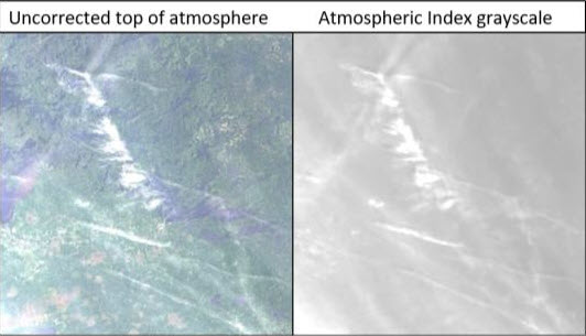
In application, the Atm-I model provides a highly accurate grayscale map that emulates visible haze but with far greater sensitivity than the human eye. Grayscale maps guide the spatial reversal of atmospheric effects.

A hazy Landsat 8 TOAR image of Ontario, Canada and Atm-I grayscale generated from it.

About the Author
Hello,
I’m Dr. David Groeneveld, founder and leader of RESOLV™. Our software atmospherically corrects smallsat data conveniently, accurately and reliably and does so in near real time. The benefits of RESOLV™ go beyond its technical capabilities. Better accuracy helps researchers, scientists, and others make smarter choices to monitor and manage our planet.
Curious to learn more about RESOLV™, the science behind it and its potential for correcting smallsat images? Fill out this short form and I’ll be in touch.
